Hammonds Plains – A Traditional Lumbering Community: A History
The first residents of Hammonds Plains were members of the Mi’Kmaq nation, who used the area as their place of residence long before the Europeans visited our province. Winter encampments were located in the area of Pockwock Lake, with summer treks to Bedford Basin a common practice.
By the mid 1700’s, with the founding of Halifax, the English had laid claim to the area surrounding emerging capital. The governing body of Nova Scotia issued original land grants to the Hammonds Plains area in 1786 to 72 land owners. The grants became known as the Hammond Plains Grant, named by the new landowners after Sir Andrew Snape Hamond (the Lieutenant-Governor of Nova Scotia from 1781-1782). Most of the original landowners were from Halifax, so they were very familiar with Hamond.
The original land grants were of extreme value to the land owners as they contained virgin forests. Many of the land owners had the forests cut and sold to the Halifax market (transported to Bedford Basin via horse or by way of the Nine Mile River and then sent to Halifax via the basin). The original grants followed a road which was to be on the main route travelling between the two main English military fortifications in the province (Halifax and Annapolis Royal).
While homes were established on some of the grants (1791 record indicates 15 land owning residents), many of the original grants were sold off during the early 1800’s without homes ever being built on them. During this time, a number of well to do families bought up the land and started to settle the lands. The most prominent families who arrived during this time became known as the founding fathers, and an active village quickly developed.
In 1815, the War of 1812 ended and the government of Nova Scotia was looking for a place to grant land for the Chesapeake Blacks, who had escaped (or in some cases, were stolen) from slavery to fight for the British against the Americans in that war. There was a promise made that if the former slaves would take up arms against the U. S., then they would be granted land at the end of the war. One of the areas chosen were the lands directly north of the village of Hammonds Plains. A group of 500 refugees moved to this area in 1815 and began carving out a community which became known as Upper Hammonds Plains. The land that was granted was the raw, barren, unworked land typical of Nova Scotia’s interior. It had the advantages of available lumber, close access to the Bedford Basin, and proximity to what was supposed to be a major highway. In 1815, the Annapolis Road was planned to be a major connecting road in the province and if that came to be, the site would be very advantageous and run right through the new community. This land had previously been granted to white settlers; however since they had not used the land or made the necessary improvements the lands were expropriated by the crown and used for the settlement of the Chesapeake Blacks. A significant part of the grant was the provision for a schoolhouse and a small house for a schoolmaster in Upper Hammonds Plains. This established education as a priority even before free public education was established.
The dream of a new Annapolis Road also caused the governor in 1816, to sell land grants to establish a new settlement north of Upper Hammonds. This settlement to be called Wellington (although better known as Kemptown) was located near Wright’s and Big Indian Lake. It developed into a thriving lumbering community during the 1800’s, even with it’s own school. However, a major fire destroyed much of the community in the late 1860’s and many of the residents chose to move away. By the 1920’s the community had dwindled to a few homes and to-day no long exists.
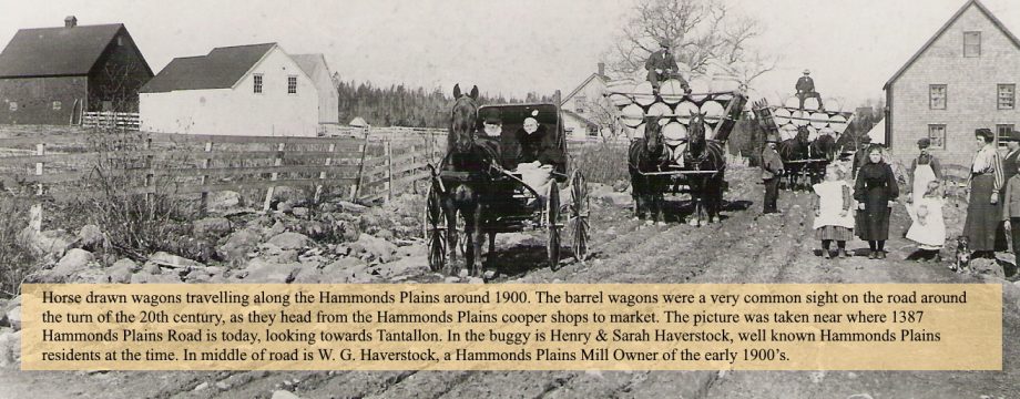
The end of the dream of becoming a prosperous settlement along the Annapolis Road came to an end during the 1830’s when the government abandoned the road project. However, the ensuing years saw the Hammonds Plains area become prosperous in another way, as it became a prominent lumbering region, with creation of mills on the many lakes and then toward the end of the century shops set up to make wood products such as barrels, shooks and wooden boxes. Copper Shops soon dotted the landscape.
The 1800’s also saw the establishment of schools, churches, inns, blacksmith shops, a Temperance Hall and small general stores within the community, with the population in both Upper and Lower Hammonds Plains showing consistent growth. The 1861 census listed 770 individuals living in the area.
The road continued to improve during the 1800’s, going from a horse trail to one where wagons could drive over. In 1831, a road running from Sackville was added to join on to the Hammonds Plains Road. This became known as the Lucasville Road. The community of Lucasville was established as a splinter group from Upper Hammonds Plains. Farming and forestry became the chief industries and soon the community had its own school and church.
Hammonds Plains was a thriving independent community by the beginning of the 21st century. The community saw on a daily basis, wagons of barrels and boxes heading to Halifax. Phones came to the community in 1902, with the community creating its own phone company, The Hammonds Plains Phone Company, originally consisting of three phones. A new community hall was built in 1912 in Lower Hammonds Plains. Cars were introduced to the community just before the First World War, with the first residents owning cars in the early 1920’s. Power lines were put through the community in 1932, bringing electricity to the area. The first half of the century saw an increasing wooden box business become an economic driver within the community, which complemented the traditional barrel making business. The community was tightly knit during this time with many community events, such as suppers, the labour day picnic and turkey shoots attended by many.
The Second World War saw the community act as a training ground for Canadian soldiers. There were two military communication stations established in the community and soldiers could be seen marching along the road. Recreation and sport has always had a big role in the community. Hunting and fishing was very popular since the beginning days, and skating was an activity enjoyed by many on the lakes and on one of the community rinks. Baseball was a common summer sport, with the community having it’s own team during the early part of the 20th century.
After the Second World War, the forestry industry started to decline, with a decreasing demand for wooden products. Mills and Cooper Shops gradually closed with only a handful left by the 1970’s.
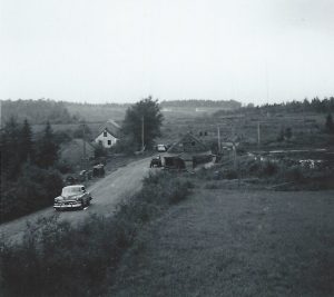
A major change to the community came in 1957, when the Hammonds Plains road was widen and paved. This opened up the road to greater traffic and new sub-divisions soon started to become the face of the community, the first being Uplands Park in 1962. Fire Departments were created in both Upper and Lower Hammonds Plains. In 1967, the Hammonds Plains Consolidated School was opened, taking in all the students of the Hammonds Plains area, thus closing the outdated Hammonds Plains and Upper Hammonds Plains Schools.
The community became a much different community during the 1960 -70’s. Businesses such as a golf course, race car track, camp ground, excavation companies, a trailer park, food places, and gas stations slowly replaced the traditional mill related commercial buildings.
The late 20th century brought tremendous growth to the community with the establishment of new subdivisions, such as Highland Park, Kingswood, Glen Arbor, Blue Mountain, White Hills, Maplewood and Waterstone. The growth has brought with it increased traffic, new business establishments, a world class golf course and a community baseball field.
Recent years have seen continued growth with the creation of further sub-divisions at Voyager Lakes, Kingswood West and North and Perry Ponds. The highway is now dotted with lights at many of the intersections, with several adjacent strip malls along the side of the road and will have a bike route in place by 2016.
![]()


